A System of Fields and Faces: Digging the Hørdalen Area in Vestfold, Norway
17 March, 2014
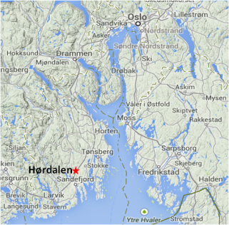
 This week On the Reading Rest I have three volumes from the Norwegian E18 project, the contract archaeology carried out between Gulli and Långåker. The volumes are impressive and they are part of the significant development of Norwegian contract archaeology that has taken place because of the many carefully designed excavation projects in connection with the new highways southeast and southwest of Oslo (0).
 Mjærum, Axel and Gjerpe, Lars Erik (eds). 2012. E18 prosjektet Gulli-Långåker. Dyrking, bosetninger og graver i Stokke og Sandefjord. E18 prosjektet Gulli-Långåker, bind 1. Oslo Fagbokforlaget.
Gjerpe, Lars Erik and Mjærum, Axel (eds). 2012. E18 prosjektet Gulli-Långåker. Jordbruksbosetning og graver i Tønsberg og Stokke. E18 prosjektet Gulli-Långåker, bind 2. Oslo Fagbokforlaget.
Gjerpe, Lars Erik (ed.). 2012. E18 prosjektet Gulli-Långåker. Oppsummering og arkeometriska analyser. E18 prosjektet Gulli-Långåker, bind 3. Oslo Fagbokforlaget.
There are almost 1,000 pages to read, but I have chosen to look at the Hørdalen Area, Site 51. This site is a field system containing cleared fields, intensive soil improvement, a droveway alignments, clearance cairns, linear cairns, etc, etc.
This means that I read two chapters:
Mjærum, Axel. Dyrkningsspor og fegate fra eldre jernalder på Hørdalen (lok. 51) In: E18 prosjektet Gulli-Långåker. Jordbruksbosetning og graver i Tønsberg og Stokke. E18 prosjektet Gulli-Långåker, bind 2. Acronym: MjAx
Cannell, Rebecca J. S. The application of multi-elementalanalysis at Hørdalen (site 51): an evaluation of methods and results. In: E18 prosjektet Gulli-Långåker. Oppsummering og arkeometriska analyser. E18 prosjektet Gulli-Långåker, bind 3. Acronym: CaRe
And the relevant section, pp. 132-147 in:
Svensson, Nils-Olof and Regnéll, Joachim. Vegetationsdynamik och merkanvändningshistoria längs vägsträckan Gulli-Langåker i Vestfold. In: E18 prosjektet Gulli-Långåker. Oppsummering og arkeometriska analyser. E18 prosjektet Gulli-Långåker, bind 3. Acronym: SveRe
The early surveys and investigations at Hørdalen, followed-up by the project designed by the contract archaeologists and the archaeometrists involved, have resulted in stimulating results that add to our knowledge and open up a window towards a more hypothetical discussions, which may be interesting in the future when it may become possible to investigate field systems and farms united as one context. In the following I will look at the results from Site 51 in relation to such a future scenario.
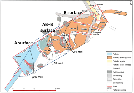
The Hørdalen area and Site 51 has been understood as a gentle W-E slope characterized by nutrient-poor soils consisting of a slightly higher A-Surface and consequently a slightly lower B-Surface. Despite the soil qualities this slope has been developed into a field system used for more than a millennium. In many ways earlier analyses have been confirmed and become less monothetic owing to the new investigations, but archaeological features, chemical multi-element analysis and paleobotanical analyses have shown that the border zone between surfaces A and B must be understood as an area in its own right dominated by clearance cairns and an oven area. In fact the AB Surface and the western part of the B Surface, which is dominated by cairns and the oven, can be seen as a transition from surface B to surface A. I will treat it as AB+B Surface as a unit creating a triparted site. Site 51 represents an agricultural space developed and used for centuries in different more or less intensive ways. The Hørdalen Area of which site 51 is just a part was probably used continuously, but when singling out site 51 a more varied usage comes to the fore.
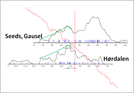
Before the beginning of the Common Era, the curves are quite similar at Gausel and Hørdalen as indicated by the parallel green lines inserted into the above illustration. It is conceivable to explain this similarity by suggesting that the investment in labour has led to a certain outcome – increase in investments leads to an increase in productivity. The period of investment belongs to a period in which Bronze and Early Iron Age farms are not yet stable, but nevertheless linked to a specific settlement area and thus able to use the same field system reaching it from different farm sites, some being more optimal in relation to the system than others.
In the beginning of the Common Era and during the following centuries, investments at Hørdalen drop, but at Gausel the outcome represented by the charred seeds found in the Gausel excavations, grows. Tentatively we may conclude that adding nutrients to the fields more effectively, for instance bringing livestock to the fields at intervals and collecting more dung in the byres, may explain the difference. Bringing manure into the fields from a stable nearby farm seems more manageable than bringing it from less stable farms with a variety of situations. However, bringing farm hands to a field system from different farms, investing labour in burning and slashing as well as in clearing the site, seems a logistically straightforward possibility already in the Bronze and Pre Roman Iron Age. Since transportation costs are low when clearing fields and making ashes on the spot, it is more easily organized than bringing in nutrients, which is expensive in terms of transportation.
Since Gausel represents a larger area than Hørdalen Site 51, which may represent nothing but itself, the seeds at Gausel probably had more sources other than just one field system. Hørdalen, therefore, could have been given up for all kinds of irrelevant reasons unknown to us, but if for the sake of the discussion, we suggest that it is more likely to fit into a general pattern, as indeed it did up and until the beginning of the Common Era, rather than a deviant one, then the expected change in farm size and settlement stability in the beginning of the Common Era could indicate a shift in labour investment from developing visible clearings to adding ‘invisible’ nutrients. Moreover, with stable farm sites, slash and burn farming will be more difficult to imagine given the deforestation that will take place around a farms with a stable position in the landscape.
Site 51 Hørdalen, with the droveway on the B Surface, indicating a nearby farm, probably 80m north of the excavation area (MjAx:187 with reference), has a place in the human landscape as well as a formation history. If we analyze the 14C dates the formation can be termed additive as well as varied.
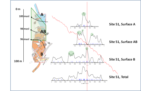
Given the dates on the different surfaces (and I do not take the problematic optically stimulated luminescence dates, the OLS, into account) the formation of the site is additive inasmuch as Surface B is the first to be developed, followed by extensions, Surfaces AB+B (framed by a green line on the map) and A. It seems significant that little by little and up and until the beginning of the Common Era investment periods gradually become shorter and more intensive. They are indicated by green shades in the above figure. Moreover, it was uncommon that investments peaked in two surfaces at the same time. As MjAx, CaRe and SveRe all point out, the site is intricate and time seems to be a decisive factor when it comes to the complexity of the site. It seems that when the system has been created it may have been and probably was used for many different agricultural purposes.
Although CaRe is cautious in her conclusions it stands to reason that the A Surface has received more nutrients as a result of anthropogenic activities than the B Surface. As a correlation to this surface character, the 14C-dates indicate a chronological dimension to the surface division suggesting (1) an earlier period of investments into the construction of cairns clearing of fields and (2) a later period in which manure was more important and investments thus less visible. As SveRe shows the fields were not used continuously, but alternating with periods when animals grazed and fertilized the fields.
*
The project designers were well-aware that they would not be allowed to link the excavation of the field system with the nearby settlement. Had this been possible the contextual knowledge produced would obviously have been more important and less expensive owing to the research design being more rational. But as long as the Scandinavian countries, where governments have copied each other’s legislation for under hundreds of years, are not prepared to fund a percentage or two of the national cost for contract archaeology to further archaeological development projects that will enhance our knowledge and make contract archaeology less expensive, archaeologists are not allowed to do better that the E18 project. Given the attitudes of heritage boards this Project level is excellent, but nonetheless a matter of little by little setting new archaeological standards whenever Chance and Circumstance makes it possible.
The reason why it is so uncommon to excavate the farm and its fields, 80 metres apart, has to do with the notion of the ancient monument. Up and until WWII ancient monuments were well-defined physical structures preserved into modern times and thus incredibly marginal inasmuch as nobody had bothered to erase them from the surface of the earth. From the 1960s and onwards the invisible human landscape and its ancient monuments, not least from the Iron Age, were recognized, and by definition an ancient monument, instead of being a monument, became an area looking like plough land, small forest and meadows. The most common monument became hectares in central parts of the modern human landscape. The past became almost as large as the present covering large areas with no definite borders. At the same time the past became unspectacular. With hardly any artefacts to show let alone grave goods the Iron Age became full of social science, subsistence economy, social structure, functional and symbolic architecture, etc. The familiar past, that is, the traditional Iron Age, could no longer be mirrored in monuments of death and thus it passed away resurrecting itself as everyday life rather than funeral feasts and burial rites. The past became loaded with its own history, kept alive for instance in field systems that had been used, developed and known for a millennium already in the beginning of the Common Era. No longer monumental, the past started to grow and its contexts became hectares rather than square metres. The heritages boards are unable to cope with the consequences.
Archaeologists know how to excavate the past, but they are seldom allowed to do it. And that is why large parts of 30 and 20 years old excavations stand out as a waste of money and most importantly as a legacy of heritage management. Many excavations have been wasted because they were never reported or because they have been buried in inaccessible archives, but quite a number are pointless because they were, from the very beginning, focussed on pointlessness.
Notes
(0) A general discussion about the multi-disciplinary design of a large contract archaeological project and Gulli-Langåker in particular can be found in:
Gjerpe, Lars Erik. 2013. Om arkeometri, en fornøyd arkeolog og jordbruk i eldre jernalder. Primitive tider 15. Pp. 33-57.


