When Darum Was Visited by the Middle Ages
16 April, 2012
This week On the Reading Rest I have a Danish article about the excavation of some Iron Age farms at Darum in Southwest Jutland. There are two reasons for reading the it: Darum is an interesting place in itself and the excavation an example of modern Danish archaeology and heritage management at its best.
Søvsø, Morten. Et udsnit af en landsby fra omkring år 500 e.Kr. udgravet i St Darum ved Ribe (A section of a village from c. 500 AD excavated at the Great Darum village, Ribe). By, marsk og geest 22:5-20 [1]

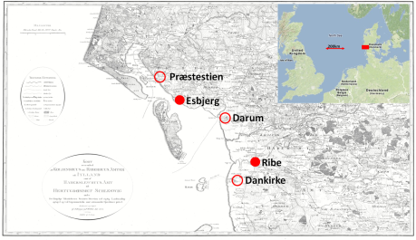
Overview. In this context Ribe and Esbjerg are modern sites, the three other ones conpemporary. The distance between Dankirka and Præstestien is 30 km.
Putting this article on the reading rest, which presently stands on a desk in Sweden, I became interested in the layout of the Darum farms. Since the excavation is modern I found the excavation report—and others from St Darum in the electronic museum archive:
http://www.sydvestjyskemuseer.dk/Files//Filer/Kulturhistoriskerapporter/ASR2253_k36_-_Bygherrerapport.pdf [2]
Morten Søvsø (MS), the director of the excavation was interested in dating the settlement by means of 14C dates and had a sample of charred plant remains analysed before choosing nine grains from different contexts and sending them to the 14C lab in Aarhus. http://phys.au.dk/forskning/ams-14c-dating-centre/
I found a report on the plant remains at
http://www.arkaeologi.dk/naturvidenskab/index.php?vis_journal=501&vis_sag=561
and
http://www.arkaeologi.dk/naturvidenskab/index.php?vis_journal=501&vis_sag=657
MS presented the nine 14C dates in his article, but since I wanted to look at the results in a slightly different way, I wrote and asked for the report from the 14C lab. I got it just a few hours later. MS referred to an article from 1985 on the first trail excavation in Darum and I went down to the open stacks and made a pdf-copy of that article too. Everything started just after lunch when I read Morten Søvsø’s article and the next day in the morning I had access to all the information I needed. I looked up Darum in the national data base Fund og fortidsminder—finds and prehistoric monuments:
http://www.kulturarv.dk/fundogfortidsminder/
and was ready to start.
These first 24 hours were a typical 21st c. Scandinavian experience based on 200 years of legislation, heritage management, public museums, national and local archives. After two centuries, there is a lot of order and access to information.

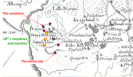
A 19th century map of Darum. The yellow dots are all the registred Iron Age finds. The green shadows represent partly contemporary villages from the centuries around 500 CE. Data from Fund og fortidsminder and Museum reports.

Darum in the 6th c. CE superimposed on Darum in the 18th. The villages are situated in more or less the same way on the hillock. Generally speaking, shifting the position of the villages over millennia give access to fertile anthropogenic soils at the old settlement sites. In the 18th c. church and churchyard is close to the old Iron Age cemetery on top of a low hill, but quite far away from the wetland votive site. Church and votive site are emblems of their respective period.
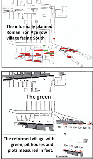
The excavations showed that what happened in Darum happened more or less similtaneously also at nearby Præstestien (lit. ‘The vicar’s path’). Let us suggest, therefore, that these events were typical of their time and place. Præstestien was an informally structured Roman Iron Age row village, one of many, a community autonomously solving its problems and a centre to itself only. Then, all of a sudden, this traditional village was regulated—enlarged and rearranged as two straight façades in which the farms were defined by the number of feet they occupied. These two new rows adjoined the village green and on the green in front of the farms there were some pit houses or sunken huts. Præstestien was defined as a village of 1320 feet divided on 11 farms – that’s 120 feet on average – but in reality one farm was 144, nine were 120 and one consequently just 96 feet.
Darum was given the same extensive makeover and thanks to context and excavation we can stick a date on it and know how long it lasted.
At Præstestien change is radical, but at Darum the traditional kinship relations, indicated by the open plots, survive the reformation of the village.
At Darum only a section of the village has been excavated, but that suffices to show that part of the same population that lived on the old farms stayed on. Unlike Præstestien, the farm land was not rearranged and the fields continued to be situated north of the village. Nevertheless there were gates and doors facing south towards the green, i.e. gates and doors in the village façade.
The second phase in Darum is the work of someone with a measuring rod and an interest in straight lines and well-defined façades regulating things. As it was the case at Præstestien, the surveyor was not satisfied with the orientation of the old village and changes it a few degrees from east-west to something east, a little to the south – west, a little to the north. The row is organized with a straight façade to the south, and in this façade the breadth of each farm is 100 feet. We cannot know how many farms there were in the reformed Darum—perhaps eight, i.e. 800 feet.
The reason why the plots are being measured is a wish to regulate and make it easy in a formal way to see and define the size of the farm in relation to the village. Traditionally, in an old village administrating itself, this was hardly a major problem and in this part of Jutland they had managed row villages without surveyors 400 years or more. Surveyors are brought in to establish the simple definition of farm and village because it is a prerequisite for meting out duties and taxes. Measuring the façades amounts to measuring the capacity of the village and the part that falls on the individual farm. If a village, similar to Præstestien, is 1320 feet then your 120-feet farm is 1/11 of the whole. That equals your duties. Regulation simply means that there are obligations, indirect or direct, to someone outside the village.
Although pit houses or sunken huts are not unknown in the Roman Iron Age they grow in number during Pre Carolingian times. Typically, they are situated on the green outside the plots. In terms of formal planning, therefore, two things happen: (1) the carrying capacity of the village and its farms is assessed and defined as a number of feet; (2) the façade separates the regulated farms from the village green—private grounds from common grounds. Since the pit houses are on the green they are not strictly speaking part of a farm inasmuch as they are not on a plot. Their situation, nevertheless, indicates that they are associated with the farms. And since they are used for production, it stands to reason that they are occupied by outsiders who worked for the farmers as craftsmen – weavers, smiths or farm hands – without being full members of the farm household. Pit house dwellers are landless people allowed to settle on the green offering their services to a farm owner at a temporal or seasonal basis. Therefore, when strict planning is introduced it looks as if the Middle Ages with lords, landed gentry, tenants and landless peasantry arrive at Præstestien and Darum, and we may wonder when that happened.
This is where the 14C-dates enter the scene. The source critical conditions are under control. The settlement was new to the site and there were only two major building phases: First, a construction phase with informally planned farms. Second, the reformed village when the plots were defines as façades with a certain breadth in feet. In both phases houses were repaired now and again, less however in the first phase, which was thus probably the shorter one. Pit houses, between three and six at one and the same time, were probably repaired, rebuilt and torn down in their own shorter cycles.
The material dated were seeds representing one year only. Since the settlement started with one farm that eventually became two before the villages was restructured, we may suggest that there was an escalation of activities in the continuous settlement. Because of the few phases MS rightly suggests that the village existed c. 50-150 years.
The nine 14C-dates were selected to represent the settlement period of the farm houses and not a certain point in time such as the beginning or the end of the settlement. The calibration curve in the time span in question is not ideal, inasmuch as it looks like a section through a slope with a flat terrace in the middle, and this indicates that a 14C-year measured in calendar years is short when the slope is steep and long when the when curve is horizontal. If it is reversed, the year is long and split. No surprisingly, looking at a single 14C-date is frustrating. But if we look at all the possibly dated years, then they make up a probability distribution that allows us to suggest that sometime during the 5th c. CE people lived in the village – perhaps earlier, perhaps later too.

The probability distribution and its calibration illustrating the 14C-date and its central 14C-year as well as the calibrated Median year.
Since it is unlikely that the dates represent a single date rather than a period, we may ask ourselves whether they represent a century. We can test this by modelling what a period such as 400-500 CE would look like if we took a seed every 10th year and dated it with a certain standard error. We will start by pointing out that in a calibrated probability distribution there will be a median year dividing the sum of all the probabilities into two—50% of the possible dates are earlier than the central year and 50% later. Therefore, we may now ask ourselves the following: what series of central 14C bp years will result in a series of probability distributions in which the 50-50 calendar year equals the series 400, 410, 420 … … 500 CE, given that the standard deviation of the tests is 43 years, i.e. the average standard deviation in the Darum sample. Finding that kind of series we can model what a period with an even production of possible 14C tests will look like and compare the observed Darum probability distribution to the modelled one.
If we begin by comparing the model period 390-510 CE to Darum, this blue distribution, fits the black Darum outline quite well, but there are too few probabilities in the beginning of the period and even in its central part. This should not come as a surprise, since the production of suitable 14C test material is hardly constant at Darum, although the excavator tried to take out samples that would give the same weight to buildings from the whole period.
If we shorten the period a little and compare the observed Darum distribution to the modelled green distribution 400-510 CE, then we get a better fit from c. 400 CE and onwards, but predictably the fit before 400 CE gets worse.
This tells us the following: For two reasons it is difficult to say when the Darum settlement started. (1) Relatively speaking fewer suitable seeds were trapped in the settlements in the beginning of the settlement period when the production of suitable 14C-material was low. (2) In the beginning of the settlement period the impact of much older material blowing in the wind and trapped by chance would be greater than later on.
There is in other words a risk of contamination and biased representation. These risks are larger in the beginning of a settlement period than in the end, if the settlement expands. The 14C-dates on the other hand suggest that the settlement came to an end in the 510s. If the end happened with an aftermath rather than abruptly, then the 14C-dates would probably conceal it, but then again the settlement would probably not have been a very important one either.
In one of the pit houses, the one excavated in the 1980s two fragmentary brooches suggested that the house may have been lived or the pit filled-up as late as the 530s. It is worth suggesting, therefore, that at least one of the farms, but not all of them, continued after the 510s. Be this as it may, in the 5th c. CE the Darum village was regulated and its plots defined. The farms became 100 feet farms and the village a village defined as a number of units.
When Beowulf saved the Danish king, allegedly c. 500 CE he was rewarded also by his own king, who gave him 7000 of land. Perhaps villages such as Darum and Præstestien were c. 2000 (feet) of land – not enough by all means – but probably worthy a lesser hero.
Does this mean that the Middle Ages started in Darum and Præstestien in the 5th century? Yes, in a way it does, but Darum and Præstestien also shows that if so, the Middle Ages lasted only a couple of generations before coming to an end in the beginning of the 6th century. I think I have read about this somewhere.
In Anglo-Saxon poems (Beowulf and the Battle of Finnsburg) there is a place called Finnsburg, a manor with a hall that is synonymous with the ‘burg’. This place is in Jutland at the coast and King Finn (cf. the poem Widsið), who rules over Jutes, is a Friesian. Finn is married to a Danish princess and this is a political marriage, because in reality both Friesian and Danish interests compete in the area. Because of the Friesian presence we may suggest that Finnsburg is on the west coast of Jutland and that fits the context of the poems too—you go there by boat and may send home Friesian warriors directly to their homes. Finnsburg is the scene of a political conflict and in the end the Danes manage to revenge themselves, conquer Finnsburg, kill Finn and his retinue and bring back the Danish queen.
There was great rejoicing and composing of memorable poems, since in the event throwing out the Friesians, the Danes established their most important national border—right-wing nationalists still defend it. Although the zone of conflict was much older, it stands to reason that after the emigration of Angles, Saxons, and Jutes, Danes and Friesians competed for power in a political vacuum in southern Jutland.
It so happens that there is an obvious archaeological candidate for fictional Finnsburg in today’s Dankirke [3], an Iron Age manorial farm 6 km south of Ribe. This farm is much older than the 5th century, but by that time it was an important place that caught the attention of Friesians as well as Danes. And it is quite possible that when conquered, it was called Finnsburg by the Friesian party and later Dankirke by the Danes.
Leaving the mythical epic echoes of the past to themselves, regulating villages in the 5th century CE may nevertheless be seen as a novelty under foreign rule trying to import one or two principles of taxation and government from the Late Antique world. Closing down the project in the early 500s fits the expansion of any national liberators. A bunch of 6th century Arminiuses succeeded in defending barbarian values against Romanized civilization once again..
______________________
Notes
[1] Summary from MS’a article in By, marsk og geest

[2] There are two reports on similar sites on the Darum hillock are:
http://www.sydvestjyskemuseer.dk/Files//Filer/Kulturhistoriskerapporter/ASR1710_Bygherrerapport.pdf
http://www.sydvestjyskemuseer.dk/Files//Filer/Kulturhistoriskerapporter/ASR_1775_Bygherrerapport.pdf
[3] http://www.archeurope.com/index.php?page=excavations-at-dankirke
or in Danish:
http://www.denstoredanske.dk/Danmarkshistorien/Danernes_land/Yngre_germansk_jernalder/F%C3%B8r_vikingerne/Dankirke_og_Nords%C3%B8handelen


